Sterling Public School
STERLING TIGERS
The Geological Morphology of Oklahoma:
Math and Science Partnership 2009
Team Members: Evie Hudson and Pam Talbert
PAMANDEVIE@AOL.COM
Background Information:


Research Question: HOW MUCH RESEARCH HAVE YOU DONE ON THE GEOLOGICAL MORPHOLOGY OF OKLAHOMA AND HOW HAVE YOU USED THAT RESEARCH IN YOUR CLASSROOM?
Purpose/Objectives: To Research and collect data on the Geological Morphology of Oklahoma
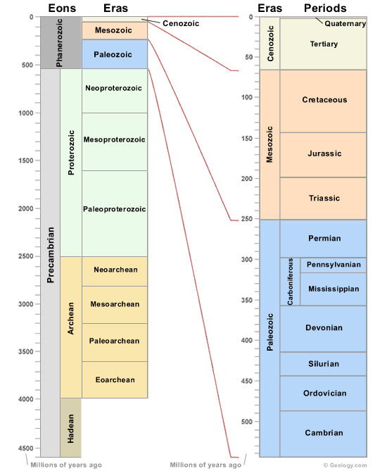
The Geological Time Scale:
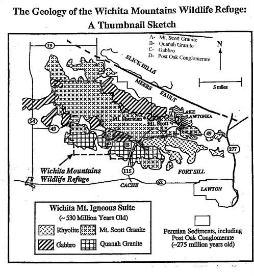
Our Research: We are going to compare the Geological Morphology of the Wichita Mountains and Beavers Bend to see if there is a direct correlation between type of rock or mineral. We are going to collect data at different Waypoints such as, GPS coordinates, elevation, type of rock and/or mineral, strike-dip and type of vegetation.
Garmin GPS Information:(of Geological Formations visited)
June 1, 2009 June 2, 2009 June 3, 2009 June 4, 2009
Fort Sill Tar Pit Lake Elmer Thomas Dam Quetone Overlook Camp Doris
N 34o 38.770’ N 34o 43.771’ N34o 43.97’ N 34o 43.051’
W 098o 20.920 W 098o 30.795’ W 098o 33.979’ W 098o 38.923’
1204 ft. 1398 ft. 1575 ft. upper 1515 ft.
1525 lower
Medicine Bluff Mt. Scott Picnic Area Boundary Between
N 34o 41.136’ N 34o 44.147’ Quanah Parker Granite
W 098o 24.921 W 098o 34.173’ and Gabbro
1180 ft. 1443 ft. N 34o 47.904’
W 098o 38.906’
Lake Lawtonka
N 34o 45.604’
W 098o 29.454’
1348 ft.
Meer’s Fault
N 34o 48.049’
W 098o 31.653’
1403 ft.
GPS Locations on the trip to Beavers Bend:
June 8, 2009 - Chickasaw National Park, Sulphur, North 34 degrees, 30 minutes, 247 seconds
West 096 degrees, 57 minutes, 028 seconds
Elevation: 1634 ft.
Beavers Bend Canoe Area, North 34 degrees, 08 minutes, 351 seconds
West 094 degrees, 41 minutes, 283 seconds
Elevation: 443 ft.
Up the Hill from the Canoe Area, North 34 degrees, 08 minutes, 463 seconds
West 094 degrees, 41 minutes, 143 seconds
Elevation: 508 ft.
June 9, 2009 - EXTREME S.E. Oklahoma North 34 degrees, 01 minutes, 950 seconds
"Diamond Mine" West 093 degrees, 40 minutes, 304 seconds
Elevation: 359 ft.
June 10, 2009- "Lost Creek" , Beavers Bend, North 34 degrees, 08 minutes, 574 seconds
West 094 degrees, 41 minutes, 556 seconds
Elevation: 422 ft.
Pictures and Slideshows:
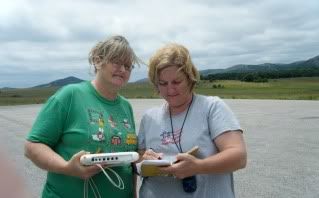
June 1 and June 2, 2009
June 3, 2009
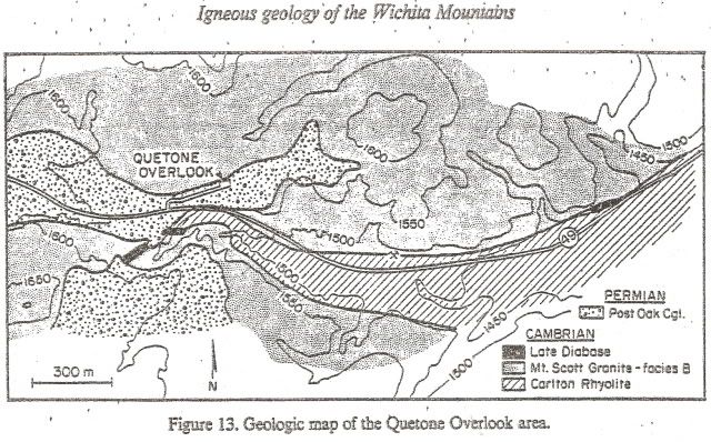
The Quetone Overlook is located off Oklahoma 49, 1.8 miles west of the intersection of Oklahoma 49 and the Mount Scott summit access road, 0.9 miles East
of Meers highway intersection. It's Geology is Post Oak conglomerate, Permian unconformity, late diabase, Mount Scott Granite, and Carlton Rhyolite.
It has a parking lot on the overlook.
It would be an excellent place to take students on a field trip. There is plenty of room to park a bus in the parking lot. The only safety issues would be to watch for traffic when they go below the overlook to study the rock formation and to be careful of poison ivy and cactus if they leave the parking lot. You could ask students to collect data such as GPS points, elevation, type of rock or mineral, strike/dip, mineral hardness, air temperature, soil temperature, soil depth, vegetation type, and vegetation location.
You could also ask them to take pictures and/or video for a presentation or ask them to use the internet to research the history of the formation.
Oklahoma Geological Society
Sample Data Table for The Quetone Overlook
| Geology |
Post Oak Conglomerate, Igneous Rock, Mt. Scott Granite |
| Strike |
SW-NE at 75 degrees |
| Dip |
SE |
| Soil Temperature |
lower level-24-26 degrees Celsius,
upper level-
23-24 degrees Celsius
|
| Vegetation |
grasses and wildflowers with shallow fibrous roots |
| Elevation Garmin GPS |
lower- 1525 ft.
upper-1575 ft.
|
| Mineral Hardness of Mt. Scott Granite |
Both knife blade and penny scratched it
|
Field Trip Video for Quetone Point and Overlook

June 4, 2009
June 8-11, 2009
Journal:
May 28 and May 29- We meet at Macarthur High School to set the framework for this years project. We received geological background information such as 90 % of the Earth is composed of 4 main elements (Fe-Iron, O-Oxygen, Si-Silicon, and Mg-Magnesium) and 99 % of the Earth's Crust is made up of 10 elements (Oxygen- 47%, Silicon-28%, Aluminum-8%, Iron-5%, Calcium-4%, Sodium-3%, Potassium-3%, Magnesium-2%, and Hydrogen-.1%). We received information about the Rock Cyce and information to help us collect and share our data.
June1- We spent the morning at Cameron University learning how to interpret graphs with the NOVA. We, also, had a presentation on The Geological Time Scale and Geological Formations. In the afternoon we traveled to the Fort Sill Tar Pit, Medicine Bluff, Lake Lawtonka, and the The Meers Fault.
June 2- We spent the morning at Cameron University and had a presentation on rock and mineral formation .We used the ball and stick models to build ions and compounds. In the afternoon we went to the Lake Elmer Thomas dam where we measured Strike and Dip. We also traveled to the Mt. Scott picnic area where we measured the elevation and slope of the area.
June 3- This morning we did a few more labs using the NOVAs. We also learned how to identify minerals using the Moh's Hardness Scale.
Mohs Hardness Scale

We found Density (using the dirt clod method). We discussed Color, Streak, Cleavage, and Fracture. We will continue tomorrow with mineral identification. In the afternoon we met at the Lake Lawtonka Day Use Area and then traveled to our assigned area to gather information and data. Our area was Quetone Overlook. We collected information such as GPS Points, Elevation, Type of Rock or Mineral, and Strike and Dip. We also used our NOVA to measure air temperature and soil temperature. We took pictures of the area and noted the types of vegetation and depth of soil.
June 4- This morning we continued with Mineral Identification. We were given a known Mineral Calcite and an unknown mineral. We found the density, cleavage, fracture, hardness, streak, and magnetism of our unknown. We identified our Mineral wrong but later figured out our unknown was Fluorite. Next, we did more lab with the NOVAs. This afternoon we traveled to Camp Doris. It was really neat. We made a wrong turn on the way and saw a mother and baby deer. On our nature walk we got to see the point where Gabbro ends and Quanah Parker Granite begins. It was interesting to see the difference in the Quanah Parker Granite and the Mt. Scott Granite. The difference is because the Quanah Parker Granite cooled slower so it has a coarser texture than the Mt. Scott Granite. The boundary between the Gabbro and Quanah Parker Granite was, also, very visible. The Granite side had mainly grasses and flowers, where the Gabbro side had trees. The reason is because the Gabbro side weathers faster and produces a deeper soil.
June 5- Today we were at Cameron in the morning. We had a presentation on how diamonds form and "Am I Prepared to Diamond Hunt?". This afternoon we returned to Macarthur to discuss and share our probable research. We also got to polish some of the rough minerals.
June 8- We traveled to Beavers Bend today. On the way we stopped at the Chickasaw National Park in Sulphur. We observed Sedimentary Rock, Travertine. This was different because in the Wichita Mountians we were used to seeing Igneous Rock. We also went to the canoe area at Beavers Bend where we measured Strike, Dip, and Elevation of the area. We observed Sedimentary rock, Sandstone and Shale which will eventually turn into Slate.
June 9- Today we traveled to EXTREME Southeastern Oklahoma to the Diamond Mine in search for fame and fortune! We didn't find any diamonds but we learned about the Volcanic activity which formed the area.
June 10- We traveled to Lost Creek "Washout" at the North end of the Mountian Fork River. We observed sedimentary rock and sandstone, and some igneous rock. We also collected data such as river width, depth, and flow velocity.
| |
Area 1 |
Area
2
|
Area
3
|
| Width |
41 ft. |
35 ft. |
60 ft. |
| Depth |
45 in. |
49 in. |
13 in. |
| Velocity |
2.5
ft/sec
|
1.37 ft./sec |
5.10
ft./sec
|
June 11- We traveled home from Beavers Bend and collected additional data as the opportunity arose!
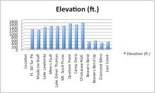
Elevations of Geographical Locations visited:
Our DVD Movie :"Where'sWaldo?: Studying the Geological Morphology of Oklahoma"
Link to the Oklahoma P.A.S.S. objectives for science: http://sde.state.ok.us/curriculum/PASS/subject/science.pdf
 for visiting our page!
You may visit the Sterling School website at http://www.sterling.k12.ok.us

THANKS TO ALL OF THE PEOPLE THAT MADE THIS PROJECT POSSIBLE !
We really appreciate all of your time, effort, and patience!


Comments (6)
Dr. Christopher Keller said
at 5:06 pm on Jun 5, 2009
Outstanding work on your site, Sterling. Great videos and graphics.
Alyssa Henley said
at 7:37 pm on Jun 10, 2009
You guys have put a lot of work into this! good job!
Alyssa Henley said
at 9:14 pm on Jun 12, 2009
I like your elevation chart. We might put one together now as well. Great idea!
Alyssa Henley said
at 9:17 pm on Jun 12, 2009
OH my goodness. Ya'lls video rocks! love it!
Cache Public School said
at 12:29 am on Sep 6, 2009
Awesome work! I love the video!
Flower Mound Public School said
at 5:43 am on Nov 26, 2009
Awesome job on the page here!! Love it.
You don't have permission to comment on this page.